Thunderbird Falls Trail — Anchorage Alaska Hiking Guide 2026
Welcome, fellow adventurers, to the wild heart of Alaska! If you’re looking for an accessible, breathtaking, and utterly iconic Alaskan experience just a short drive from the city, then the **Thunderbird Falls Trail near Anchorage, Alaska** is an absolute must-do. As a local, I’ve walked this path countless times in every season, marveling at the sheer beauty of Eklutna River canyon and the magnificent waterfall that gives this trail its name. This isn’t just a walk in the woods; it’s a quintessential Alaskan day hike, perfect for families, casual strollers, or anyone eager to soak in some pristine wilderness without committing to an epic multi-day trek. Prepare to be enchanted by one of Southcentral Alaska’s most beloved natural wonders, easily reached and unforgettable.
### Quick Trail Stats
* **Distance:** Approximately 1.8 miles roundtrip (out and back) to the main observation deck. An optional, steeper extension takes you closer to the falls and river, extending the distance slightly.
* **Elevation Gain:** Around 350-400 feet. The trail itself is mostly flat with a gentle decline towards the falls, but the return is an uphill climb.
* **Difficulty:** Easy to Moderate. The main trail is very accessible, but the final descent to the falls’ viewing platforms involves some stairs and a moderate slope. The optional river access trail is steep and often slippery.
* **Estimated Time:** 1 to 2 hours, depending on your pace and how long you linger at the falls.
* **Dogs:** Allowed and welcome, but must be kept on a leash at all times.
* **Fee:** No entrance fee or parking fee required.
* **GPS Coordinates:** 61.4727° N, 149.2611° W (Approximation for the parking area/trailhead). You can simply search “Thunderbird Falls Trailhead” on Google Maps.
### Getting There — Trailhead & Parking
Reaching Thunderbird Falls Trailhead from Anchorage is straightforward and scenic. You’ll head north on the Glenn Highway (AK-1 N), a major thoroughfare that offers stunning views of the Chugach Mountains to your east and Knik Arm to your west.
**Directions from Anchorage:**
1. From downtown Anchorage, get on AK-1 N / Glenn Highway.
2. Drive approximately 25-30 miles north. You’ll pass Eagle River and continue through increasingly rugged and beautiful terrain.
3. Take Exit 25 for Eklutna/Thunderbird Falls. This exit will be clearly marked.
4. At the end of the exit ramp, turn left onto Old Glenn Highway.
5. Drive for about 0.2 miles, and the paved parking lot for Thunderbird Falls Trail will be on your right.
**Parking:** The trailhead features a relatively large, paved parking lot that can accommodate numerous vehicles. On busy summer weekends or sunny days, it can fill up, so arriving earlier in the day is always a good strategy. There are usually designated accessible parking spots. As of my last visit, there are pit toilets available at the trailhead, which are generally well-maintained. Always pack out anything you pack in, and if the bins are full, take your trash with you.
### Trail Description — Mile by Mile
The Thunderbird Falls Trail offers a delightful journey through spruce and birch forests, eventually leading to the powerful cascading waters of Thunderbird Falls. Here’s what you can expect:
* **The Start (Mile 0.0 – 0.5):** From the parking lot, the trail begins as a wide, well-maintained path. It’s mostly flat or very gently sloping, initially paved and then transitioning to a packed gravel surface. You’ll walk beneath a canopy of towering trees, often surrounded by lush undergrowth in summer or a quiet, snow-covered wonderland in winter. Interpretive signs along this section provide interesting facts about the local flora, fauna, and geology. This initial stretch is very easy and perfect for getting into the rhythm of the hike.
* **Gentle Descent & Forest Views (Mile 0.5 – 0.8):** As you continue, the trail narrows slightly but remains well-defined. You’ll begin a gradual descent through the forest, catching glimpses of the Eklutna River canyon far below through the trees. The air often grows cooler here, particularly as you approach the canyon’s edge. Listen for the distant roar of the falls, a subtle hint of the natural power awaiting you.
* **The Approach to the Falls (Mile 0.8 – 0.9):** The final section before the main viewing platform becomes noticeably steeper. There are usually well-constructed wooden stairs or a switchback path to assist with the descent. This is where you really start to feel the elevation change. The trail surface here can be muddy or icy depending on the season, so watch your footing. You’ll soon arrive at the first, upper viewing platform.
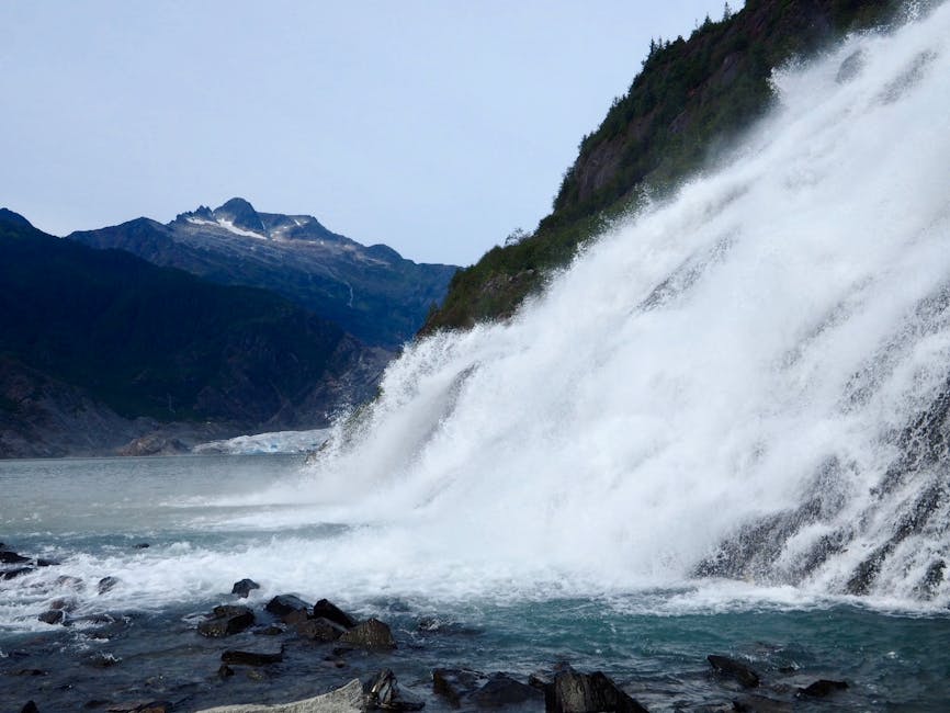
* **Main Observation Deck (Mile 0.9):** This elevated, sturdy wooden deck provides a fantastic, unobstructed view of Thunderbird Falls as it plunges approximately 200 feet into the Eklutna River canyon. The spray from the falls creates a refreshing mist, especially on warmer days. This is the primary turnaround point for most hikers and offers excellent photo opportunities.
* **Optional River Access Trail (Mile 0.9 – 1.0):** For those seeking a closer encounter, a steep, often slippery, and unimproved spur trail descends further down to the banks of the Eklutna River, directly below the falls. This section is significantly more challenging, involves scrambling over rocks and roots, and can be precarious, especially in wet or icy conditions. While it offers a unique perspective of the falls from below and access to the river’s edge, it’s not recommended for everyone, particularly young children, those with mobility issues, or in poor weather. **Exercise extreme caution if you choose this option.**
* **The Return (Mile 1.0 – 1.8):** After soaking in the views, you’ll retrace your steps. Remember that the gentle descent to the falls now becomes a gradual uphill climb back to the trailhead. While not overly strenuous, it’s enough to get your heart rate up. Enjoy the reverse perspective of the forest, perhaps spotting something you missed on the way down.
### Difficulty Rating
Thunderbird Falls Trail is widely considered an **Easy** hike, making it incredibly popular for families with young children, older adults, and those new to hiking.
Here’s why:
* **Well-Maintained Path:** The primary trail is broad, clear, and generally in excellent condition, starting with pavement and transitioning to packed gravel.
* **Minimal Elevation Gain:** While there is an overall elevation change of about 350-400 feet, this is spread out over the distance, and the majority of the trail is a gentle grade. The steepest sections are near the falls viewing areas, where stairs and switchbacks help manage the slope.
* **Short Distance:** At less than 2 miles roundtrip, it’s a manageable distance for most fitness levels, allowing plenty of time to enjoy the scenery without exhaustion.
**However, some considerations elevate it slightly for certain individuals or conditions:**
* **The Final Descent/Ascent:** The section leading down to the main falls viewing deck, and especially the return climb, can be challenging for those with limited mobility or very young children who might need assistance.
* **Winter Conditions:** In winter, the entire trail can become snow-packed and extremely icy, drastically increasing the difficulty. Microspikes or Yaktrax are essential for safe travel during these months.
* **Optional River Access:** The steep, unmaintained spur trail to the river below the falls is more akin to a **Moderate-Difficult** scramble and should only be attempted by experienced hikers with good footwear.
Overall, if you stick to the main trail, it’s a truly enjoyable and accessible outing for almost everyone.
### Best Time to Hike — Month by Month
\n
🏔 More Anchorage Trail Guides
Flattop Mountain Trail
2.8mi · Moderate · Anchorage’s most iconic hike
Bird Ridge Trail
4.8mi · Hard · Stunning Turnagain Arm views
Crow Pass Trail
7mi · Hard · Glacier views & alpine lakes
Thunderbird Falls Trail
2mi · Easy · Perfect for families
Williwaw Lakes Trail
12mi · Hard · Remote alpine lakes
Best Hikes in Anchorage 2026
Complete guide to top 20 trails
Ready for your next Alaskan adventure? Explore more trails on AnchorageHikes.com!
\n