🗺️ Trail Route Map
Topo map data © OpenTopoMap / OpenStreetMap contributors · View All Alaska Trails →
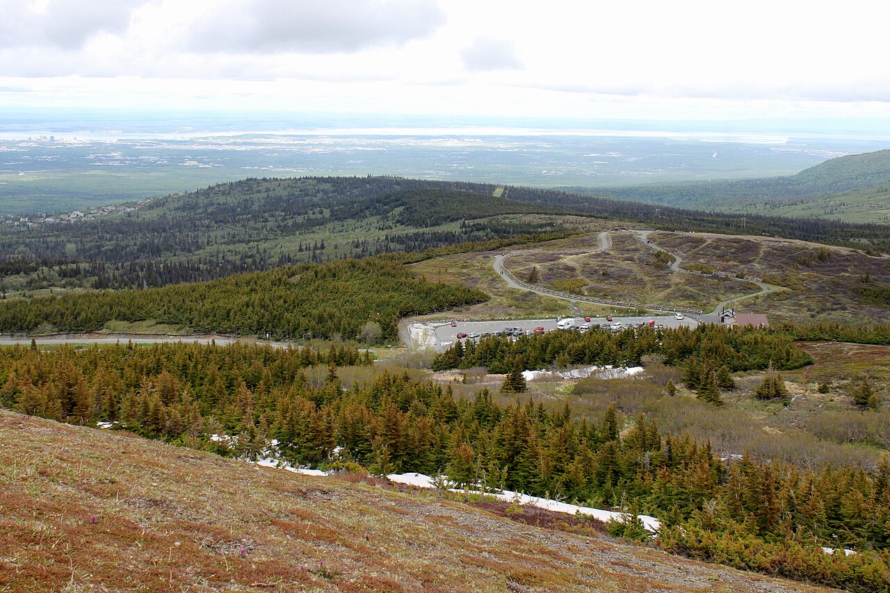
📍 Trailhead Location
Flattop Mountain Trail — Complete Anchorage Hiking Guide
Everything you need to know about Anchorage’s most iconic summit hike — trail conditions, GPS, tips, and more.
Flattop Mountain Trail Guide
Anchorage’s most climbed peak – 3,510 ft summit, 3.4 miles RT, 1,350 ft gain
Flattop Mountain is a popular hiking destination located near Anchorage, Alaska. The mountain offers stunning views of Cook Inlet, Denali on clear days, Knik Arm, and the Alaska Range. The trail is 3.4 miles round trip and gains 1,350 feet in elevation, with a summit elevation of 3,510 feet.
Trail Description
The Flattop Mountain Trail is a well-maintained trail that starts at the Glen Alps Trailhead. The trail is 1.7 miles to the summit, with a steep climb in the last 0.5 miles. The trail begins in a forested area, with a gradual incline. As you climb higher, the trees become smaller and more sparse, and the views of the surrounding landscape become more expansive.
At the 0.5 mile mark, the trail begins to steepen, and the climb becomes more strenuous. The trail is well-marked, but it can be rocky and uneven in some areas. At the 1.2 mile mark, the trail reaches a ridge, where the views of Cook Inlet and the surrounding mountains become breathtaking.
The final 0.5 miles to the summit is the most challenging part of the hike. The trail becomes very steep, and the climb involves scrambling over rocks and uneven terrain. The views from the summit are well worth the effort, with stunning vistas of Denali, Knik Arm, and the Alaska Range on clear days.
Mile-by-Mile Trail Description
- Mile 0.0: Start at the Glen Alps Trailhead, with a $5 parking fee. Arrive early, as parking can fill up quickly.
- Mile 0.5: The trail begins to steepen, with a more strenuous climb.
- Mile 1.2: Reach the ridge, with stunning views of Cook Inlet and the surrounding mountains.
- Mile 1.7: Reach the summit, with breathtaking views of Denali, Knik Arm, and the Alaska Range on clear days.
Route Options
There are three route options to the summit of Flattop Mountain: the main trail, the northeast ridge, and the direct route.
The main trail is the most popular route, and it is well-marked and well-maintained. The northeast ridge route is more challenging, with a steeper climb and more uneven terrain. The direct route is the most strenuous, with a very steep climb and scrambling over rocks and uneven terrain.
Views
The views from the summit of Flattop Mountain are breathtaking. On clear days, you can see Denali, the highest peak in North America, as well as the stunning vistas of Cook Inlet, Knik Arm, and the Alaska Range.
The views of the surrounding landscape are equally impressive, with the Chugach Mountains rising up to the east and the Kenai Mountains to the south. The views of the inlet and the arm are stunning, with the opportunity to see wildlife such as beluga whales and sea lions.
Wildlife
Flattop Mountain is home to a variety of wildlife, including Dall sheep, which can be seen grazing on the rocky slopes. Other wildlife that can be seen in the area includes moose, bears, and eagles.
Seasonal Notes
The Flattop Mountain Trail is accessible year-round, but the best time to hike is from June to September, when the weather is warm and the trail is dry. From October to May, the trail can be icy and snowy, and crampons and ice axes may be necessary.
GPS and Map
The GPS coordinates for the summit of Flattop Mountain are 61.0543N, -149.7283W. You can also use Google Maps to navigate to the trailhead, with the following link: https://www.google.com/maps/dir/?api=1&destination=61.0543,-149.7283
What Locals Say
“Go on a Tuesday morning for no crowds. The views are stunning, and the trail is well-maintained. Bring plenty of water and snacks, and be prepared for changing weather conditions. Don’t forget your camera, as the views from the summit are breathtaking!”
Warning
The last 200 feet of the hike involves scrambling over rocks and uneven terrain. Don’t wear flip flops or sandals, as the terrain can be hazardous. People get rescued from this mountain every summer, so be prepared and use caution. Bring plenty of water and snacks, and let someone know your itinerary before you start your hike.
FAQ
- Q: How long does it take to hike to the summit of Flattop Mountain?
- A: The hike to the summit of Flattop Mountain typically takes 2-4 hours, depending on your level of fitness and the amount of time you spend at the summit.
- Q: What is the best time of year to hike Flattop Mountain?
- A: The best time to hike Flattop Mountain is from June to September, when the weather is warm and the trail is dry.
- Q: Are there any bears on Flattop Mountain?
- A: Yes, there are bears on Flattop Mountain, including black bears and grizzly bears. Be sure to make noise while hiking and keep a clean campsite to avoid attracting bears.
- Q: Can I bring my dog on the hike?
- A: Yes, dogs are allowed on the Flattop Mountain Trail, but they must be kept on a leash and under control at all times.
- Q: Are there any restrooms or amenities at the trailhead?
- A: Yes, there are restrooms and potable water at the Glen Alps Trailhead, as well as a small parking lot and a picnic area.
🧭 Explore More on AnchorageHikes.com
Chugach State Park ↗
🥾 Explore More Anchorage Trails
❓ Frequently Asked Questions — Flattop Mountain Trail Guide — Anchorage Alaska 2026
What is the difficulty level of the Flattop Mountain Trail?
The Flattop Mountain Trail is considered a moderately difficult hike, with a steep incline and uneven terrain. The trail is approximately 3.5 miles round trip and gains about 1,700 feet in elevation. Hikers should be in good physical condition and wear sturdy hiking boots or shoes with good traction.
What is the best time to visit the Flattop Mountain Trail?
The best time to visit the Flattop Mountain Trail is from June to September, when the weather is typically mild and dry. However, hikers should be prepared for changing weather conditions, as sudden rain or snowstorms can occur even in the summer months. It’s also a good idea to check the trail conditions before heading out, as the trail may be closed due to snow or maintenance.
What should I bring and know before hiking the Flattop Mountain Trail?
Hikers should bring sturdy hiking boots, layers of clothing, and plenty of water and snacks, as well as a map and compass or GPS device. It’s also a good idea to let someone know your itinerary and expected return time, and to be aware of potential hazards such as steep drop-offs and wildlife encounters. Additionally, hikers should be prepared for changing weather conditions and have a plan in place in case of an emergency.
Dena’ina Athabascan History
Flattop Mountain, known to the Dena’ina people as “Tikishla,” meaning “the hill” or “good mountain,” holds significant cultural importance for the indigenous people of Southcentral Alaska. The Dena’ina people have lived in this region for over 1,000 years, and the Chugach area, where Flattop Mountain is located, was central to their culture and way of life. The Dena’ina Elnena, or “the people’s land,” extends from Cook Inlet to the Alaska Range, encompassing a vast and diverse landscape that has been home to the Dena’ina people for centuries.
Geology
Flattop Mountain is primarily composed of sedimentary rock from the Knik Arm Formation, which was formed during the Triassic and Jurassic periods, approximately 200 million years ago. The characteristic flat top of the mountain was carved out by glacial sculpting during the last ice age, also known as the Wisconsin glaciation, which ended around 12,000 years ago. The “scramble zone” at the summit of Flattop Mountain is made up of loose sedimentary conglomerate, requiring careful footing and attention to safety.
Trailhead Information
The correct trailhead for Flattop Mountain is located at Glen Alps, not Prospect Heights. The address is 8300 Toilsome Hill Drive, Anchorage, AK, and the GPS coordinates are 61.1004° N, 149.7056° W. There is a $5 daily parking fee, and the parking lot has over 50 spaces, but it tends to fill up quickly, often by 9 am on summer weekends. As an alternative, hikers can park at Hillside Park, which is free, and walk up to the Glen Alps trailhead.
Trail Junction at the Summit
At the top of Flattop Mountain, there is a Y-junction that can be easily overlooked. The left path leads to the Flattop summit proper, which involves a scramble up loose rock. The right path continues on to Blueberry Hill and the Powerline Pass route, offering additional views and hiking opportunities. Many people are unaware that they can continue past Flattop Mountain along the ridge for even more spectacular views.
Difficulty Breakdown
The Flattop Mountain trail can be broken down into three sections, each with its own unique characteristics and challenges. The lower trail, from 0-1.5 miles, is well-maintained and easy to navigate, making it suitable for hikers of all fitness levels. The elevation gain during this section is approximately 500 feet.
- Lower trail (0-1.5 miles): Well-maintained gravel, easy, suitable for all fitness levels, elevation gain ~500 feet
- Upper trail (1.5-2 miles): Rocky, loose gravel, steeper, moderate difficulty
- Summit scramble (final 0.25 miles): Requires using hands, Class 3 scramble, NOT a hike, unsuitable for dogs or children under 8
Views from the Summit
On a clear day, the views from the summit of Flattop Mountain are breathtaking. Looking north, hikers can see the Knik Arm and the Matanuska-Susitna Valley, and on exceptionally clear days, Mount McKinley (Denali) is visible 130 miles away. To the west, the views include Cook Inlet, the Alaska Range, and the Fire Island wind farm, with beluga whales sometimes visible in Knik Arm with binoculars. To the south, hikers can see Turnagain Arm, the Kenai Peninsula mountains, and the Chugach Mountains extending south. To the east, the views are of the Chugach Mountains interior, a vast wilderness with no roads for hundreds of miles.
Winter Hiking
The Flattop Mountain trail is hikeable year-round, but winter hiking requires special gear and precautions. From November to April, crampons are necessary, and microspikes are adequate for the lower trail, but full crampons are required for the summit scramble. There is also a risk of avalanches on the upper slopes after heavy snowfall, so it’s essential to check the Alaska Avalanche Center before heading out. Despite the challenges, winter hiking on Flattop Mountain can be incredibly rewarding, with smaller crowds and beautiful snowy views. However, it’s crucial to be prepared for extreme cold, with temperatures sometimes dropping to -15°F at the summit in January.
- Trail is hikeable year-round, but requires crampons November through April
- Microspikes adequate for lower trail; full crampons for summit scramble
- Avalanche risk on upper slopes after heavy snowfall — check Alaska Avalanche Center
- Winter crowds are actually smaller — beautiful snowy views
- Sunset times: 3:45 PM in December — go early!
- Temperature can be -15°F at summit in January — full winter gear essential
Photography Tips
Flattop Mountain offers a wide range of photography opportunities, from stunning mountain vistas to vibrant wildflowers and city lights. The best light for photography is during the golden hour, which occurs before sunset, around 8:30-10:30 PM in midsummer. Alpenglow, the pink light on the Chugach peaks at sunset, is also a spectacular sight from any point on the trail. For a dramatic shot of Denali, come in March or April, when the days are clearer, and the snow on the mountain is more pronounced. Wildflower shots are best taken in late June, around 1-1.5 miles up the trail. And for a unique perspective, come after 11 PM in late August or September to capture the city lights of Anchorage twinkling below.
- Best light: Golden hour before sunset (8:30-10:30 PM in midsummer)
- Alpenglow: Pink light on Chugach peaks at sunset — stunning from any point on trail
- Denali shot: Come in March or April (clear days more common, snow on Denali dramatic)
- Wildflower shots: Late June, 1-1.5 miles up the trail
- City lights: Come after 11 PM in late August/September — Anchorage sparkles
📥 Download This Guide as PDF
Get the full guide + all 8 Alaska hiking PDFs delivered free to your inbox.
No spam. Just trails. Unsubscribe anytime.
Frequently Asked Questions
Is Flattop Mountain Trail open in 2026?
Yes, the Flattop Mountain Trail is generally open in 2026, but conditions can change rapidly due to snow and ice. Always check the Anchorage Municipality’s Parks & Recreation website or call the visitor center for the most up-to-date trail status before heading out, especially during the shoulder seasons (spring and fall).
What’s the elevation gain on the Flattop Mountain Trail?
The Flattop Mountain Trail has a significant elevation gain of approximately 1,300 feet over 4.5 miles roundtrip. Be prepared for a strenuous hike with consistent uphill climbs, and remember to pace yourself and stay hydrated.
What kind of weather should I expect on Flattop Mountain?
Weather on Flattop Mountain can change dramatically in a short period, even in summer. Expect potential for rain, wind, and temperature fluctuations, so pack layers of clothing, waterproof gear, and be prepared for colder conditions at the summit.
How do I get to the Flattop Mountain Trailhead?
The Flattop Mountain Trailhead is located off Palmer-Johnson Drive in Anchorage, easily accessible by car. Parking can be limited, especially on weekends, so arrive early or consider using public transportation to the nearby bus stops.